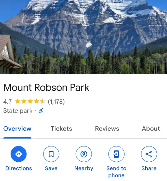
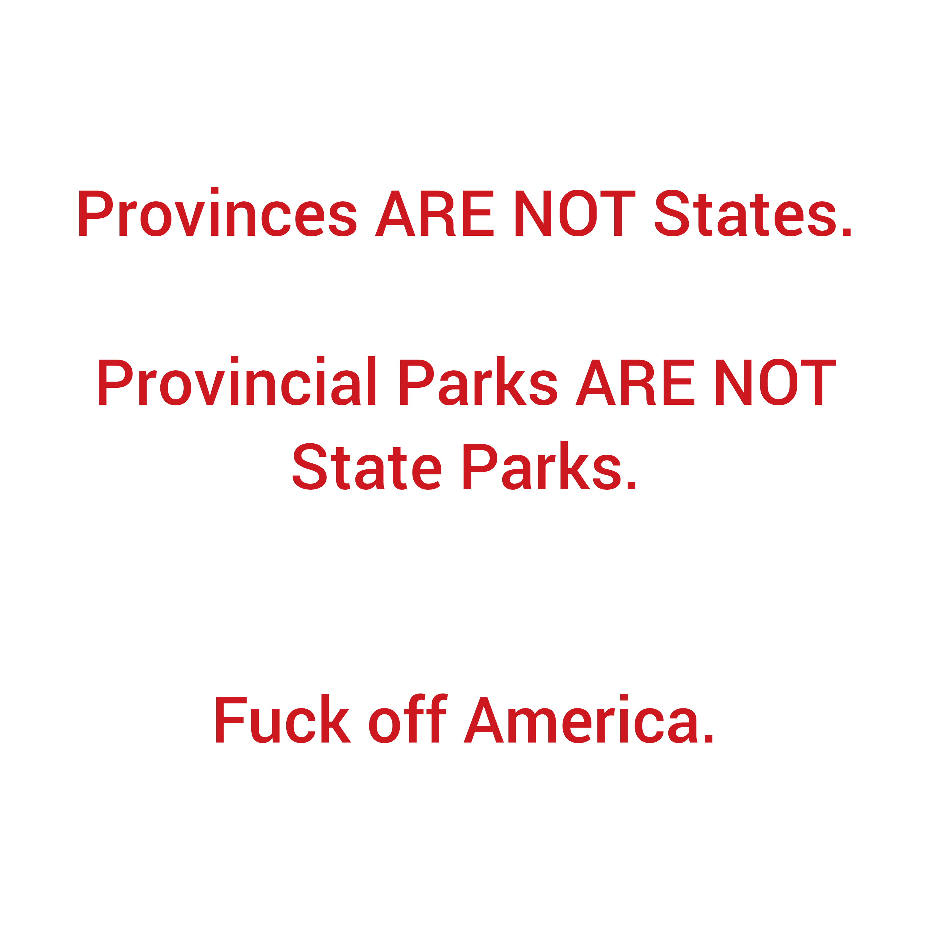
Canada really needs to develop its technology to get off of oppressive American tech. We need to work with other countries and develop our own tech to combat this. Absolutely insulting. Just a little “oopsie” after over a decade of not having mislabelled parks? The stink is showing.
this post was submitted on 24 Feb 2025
2 points (100.0% liked)
Canada
10035 readers
622 users here now
What's going on Canada?
Related Communities
🍁 Meta
🗺️ Provinces / Territories
- Alberta
- British Columbia
- Manitoba
- New Brunswick
- Newfoundland and Labrador
- Northwest Territories
- Nova Scotia
- Nunavut
- Ontario
- Prince Edward Island
- Quebec
- Saskatchewan
- Yukon
🏙️ Cities / Local Communities
- Calgary (AB)
- Comox Valley (BC)
- Edmonton (AB)
- Greater Sudbury (ON)
- Guelph (ON)
- Halifax (NS)
- Hamilton (ON)
- Kootenays (BC)
- London (ON)
- Mississauga (ON)
- Montreal (QC)
- Nanaimo (BC)
- Oceanside (BC)
- Ottawa (ON)
- Port Alberni (BC)
- Regina (SK)
- Saskatoon (SK)
- Thunder Bay (ON)
- Toronto (ON)
- Vancouver (BC)
- Vancouver Island (BC)
- Victoria (BC)
- Waterloo (ON)
- Windsor (ON)
- Winnipeg (MB)
Sorted alphabetically by city name.
🏒 Sports
Hockey
- Main: c/Hockey
- Calgary Flames
- Edmonton Oilers
- Montréal Canadiens
- Ottawa Senators
- Toronto Maple Leafs
- Vancouver Canucks
- Winnipeg Jets
Football (NFL): incomplete
Football (CFL): incomplete
Baseball
Basketball
Soccer
- Main: /c/CanadaSoccer
- Toronto FC
💻 Schools / Universities
- BC | UBC (U of British Columbia)
- BC | SFU (Simon Fraser U)
- BC | VIU (Vancouver Island U)
- BC | TWU (Trinity Western U)
- ON | UofT (U of Toronto)
- ON | UWO (U of Western Ontario)
- ON | UWaterloo (U of Waterloo)
- ON | UofG (U of Guelph)
- ON | OTU (Ontario Tech U)
- QC | McGill (McGill U)
Sorted by province, then by total full-time enrolment.
💵 Finance, Shopping, Sales
- Personal Finance Canada
- BAPCSalesCanada
- Canadian Investor
- Buy Canadian
- Quebec Finance
- Churning Canada
🗣️ Politics
- General:
- Federal Parties (alphabetical):
- By Province (alphabetical):
🍁 Social / Culture
- Ask a Canadian
- Bières Québec
- Canada Francais
- Canadian Gaming
- EhVideos
- First Nations
- First Nations Languages
- Give'r Gaming (gaming)
- Indigenous
- Inuit
- Logiciels libres au Québec
- Maple Music (music)
Rules
- Keep the original title when submitting an article. You can put your own commentary in the body of the post or in the comment section.
Reminder that the rules for lemmy.ca also apply here. See the sidebar on the homepage: lemmy.ca
founded 4 years ago
MODERATORS
The geodata and related open source technology to edit, review, and host it is already available from openstreetmap community
We have. Only it’s not well known, because of Google’s monopoly.
Then let’s start naming them and putting them out there. If they’re just maps but we need guis for apps on these, then it’s a great time to start that process and get developers in on it, preferably open sourced if possible.
My guess is there would be lots of developers willing to work on a project like this to help distance us from America.
Organic Maps and OSMAnd are phone apps. You can use Street Complete which is like Pokemon GO but improves the maps in your area.
Open source options exist. We just need more people using OpenStreetMaps and shit.
As much as i try to update OSM with local knowledge, there's no way to keep OSM reasonably up to date without automation tools.
I'm not sure how OSM can replicate whatever tools google uses to constantly update open/close hours, new/dead businesses, bus stops with schedules, etc.
This is all just crowd sourced no? Like after I visit a place google will ask me a bunch of questions about it (eg. "Did they sell X here?").
A government funded utility that utilizes regional GIS and aerial mapping would go a long way. Google's got the upper hand on directions and traffic reporting though, so that would take more time to make effective. A lot of that is genuinely due to the number of users that exist on the platform though. I think if you tried to implement similar location data analysis for government infrastructure, people would be up in arms at the idea, despite being perfectly happy to provide the same data to Google.
It's unfortunate that Google is as prevalent a default service as they are, but it's hard to ignore how good a service they offer, and how long the development period has been to get them there.
Yeah people have to start using OpenMaps more, and OSMAnd app alternative for navigation
Yep! I recently created an account with https://www.openstreetmap.org/ and started mapping my local area. Fuck Google.
I have been using the StreetComplete app that ties to that. It is actually helpful because I noticed some bad information on the local maps that was very easy to correct in the app.
Yeah! StreetComplete is great! They really make it easy to improve the maps. It's even motivated me to get out and walk more so I can complete the little quests.
Relevant communities:
Time to update your community on Open Street Map and start using Street Complete so people around you can switch to Open Street Map apps. All it takes is a couple active editors to make a town viable.
Can you please go burn down the White House again?
I'm not seeing this at all.
Provincial Parks in BC are all still called 'xyz provincial park'.
If you explicitly search for 'state park' all the provincial ones come up, but there's nothing in any of their details mentioning 'state' in anyway.
/edit: found it.
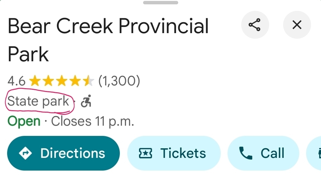
It's subtle, but it's there.

They don't let you specify in the 'edit suggestion' what it should be; but they let you add images.
/edit submitted one for every park in BC.